File:Kruger Nationalpark (de).png
Jump to navigation
Jump to search
Size of this preview: 270 × 599 pixels. Other resolutions: 108 × 240 pixels | 216 × 480 pixels | 934 × 2,071 pixels.
Original file (934 × 2,071 pixels, file size: 2.44 MB, MIME type: image/png)
Captions
Captions
Add a one-line explanation of what this file represents
| Description |
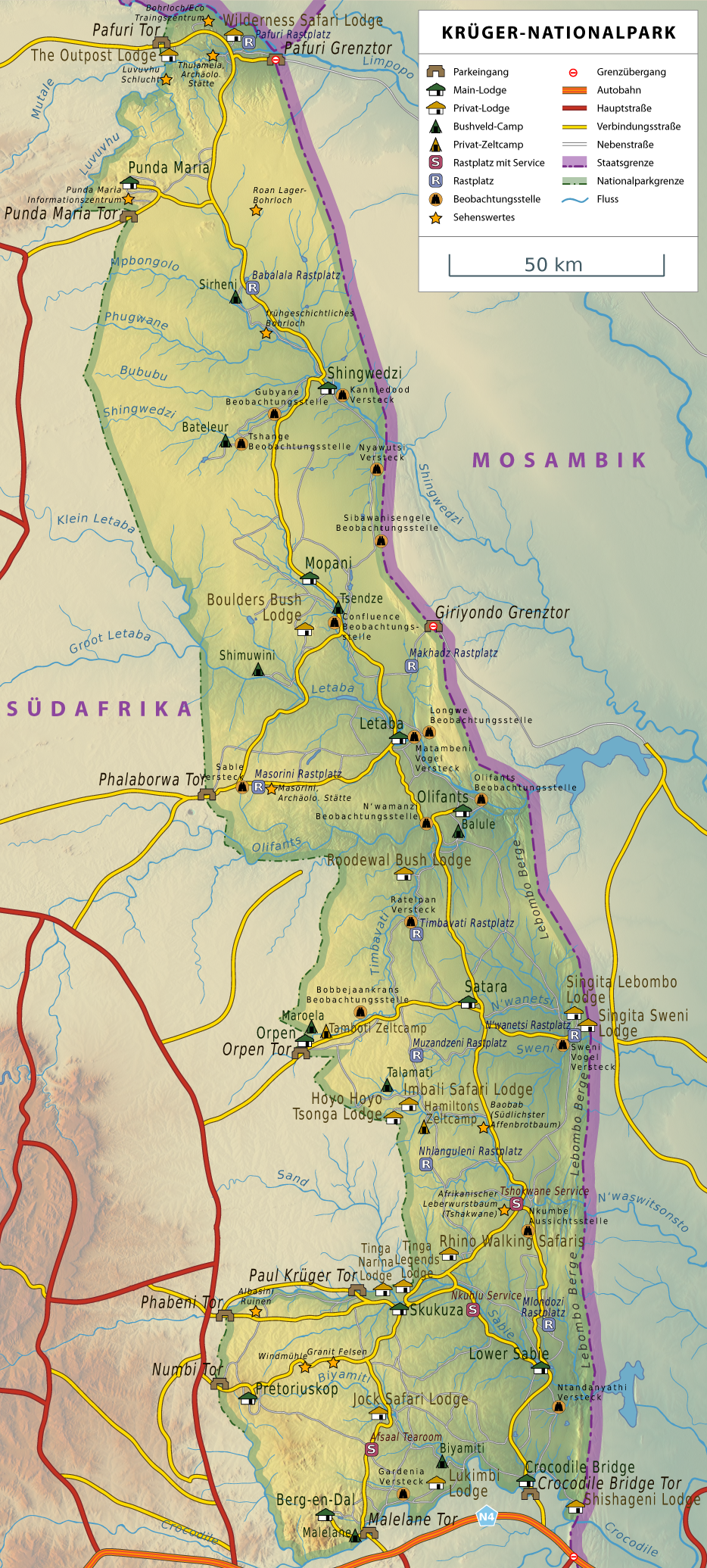
English: Map of the Kruger National Park in South Africa with the Gates and Camps in German.
Deutsch: Karte des Krüger Nationalpark mit den Eingängen und Camps auf Deutsch.
Afrikaans: Kaart van die Nasionale Kruger Wildtuin in Suid-Afrika met hekke en kampe aangedui in Duits |
||
| Date | |||
| Source | Reliefkarte aus maps-for-free.com generiert. | ||
| Author | TomGonzales | ||
| Permission (Reusing this file) |
I, the copyright holder of this work, hereby publish it under the following licenses:
This file is licensed under the Creative Commons Attribution 3.0 Unported license.
You may select the license of your choice. |

File history
Click on a date/time to view the file as it appeared at that time.
| Date/Time | Thumbnail | Dimensions | User | Comment | |
|---|---|---|---|---|---|
| current | 17:16, 16 March 2014 | | 934 × 2,071 (2.44 MB) | Kopiersperre (talk | contribs) | -2,5% |
| 22:26, 23 June 2011 |  | 934 × 2,071 (2.51 MB) | TomGonzales (talk | contribs) | Genauere und detailreichere Version. | |
| 12:04, 13 June 2011 |  | 875 × 1,500 (1.34 MB) | TomGonzales (talk | contribs) | +Privat-Lodges +Grenzübergänge Tippfehler | |
| 10:09, 13 June 2011 |  | 875 × 1,500 (1.34 MB) | TomGonzales (talk | contribs) | versch. modifizierungen | |
| 20:15, 30 May 2011 |  | 792 × 1,357 (1.23 MB) | TomGonzales (talk | contribs) | {{Information |Description ={{en|1=Map of the Kruger National Park in South Africa with the Gates and Camps in German.}} {{de|1=Karte des Krüger Nationalpark mit den Eingängen und Camps auf Deutsch.}} |Source =Reliefkarte aus [http://www.map |
You cannot overwrite this file.
File usage on Commons
The following 2 pages use this file:
File usage on other wikis
The following other wikis use this file:
- Usage on ar.wikipedia.org
- Usage on de.wikipedia.org
- Usage on nl.wikipedia.org
- Usage on pl.wikipedia.org
- Usage on pl.wikivoyage.org
.png&oldid=784839280)